These are itineraries to enjoy slowly, savoring the panoramas, far from big tourist flows, where time acquires a different value. The local communities too, the people you meet in the farmstays and inns or in the upland grazing grounds, where they make cheese, are an important part of the experience.
SENTIERO DEI RODODENDRI (Rhododendron Path) (1 hour, easy, height difference 135 m)
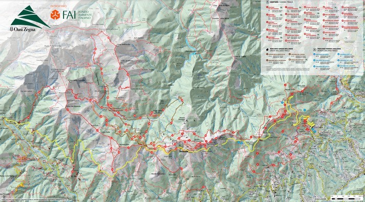
From the third hairpin on the Panoramica Zegna road (838 m), above Trivero, at Baso (912 m)
A fairly short walk in the Valle dei Rododendri, very rich in exotic and ornamental plants, with spectacular blossoming in spring. This route can be extended by taking in the loop around Colle Craviolo, where there is an Mountain Cemetery.
View the map
Download the map
SENTIERO DELLE MORE (Blackberry Path) (2 hours, easy, height difference 175 m)
From the Bellavista hairpin (1,009 m) to Oro (1,181 m)
This route follows an unsurfaced road that climbs gently and constantly over the wooded ridges of the south flank of Monte Rubello, with vast panoramas across the plains: an easy and relaxing walk whose highlight is reaching the level ground at Oro, one of the places least frequented by tourists but one of the most interesting and panoramic in Oasi Zegna, and a favorite among the people of Trivero.
View the map
Download the map
SENTIERO DELLA CIVETTA (Little Owl Path) (1h30’, easy, height difference 100 m)
From the eighth and last hairpin on the Panoramica (1,155 m) to Bocchetta di Stavello (1,206 m)
With extensive views over Coggiola and Valle Sessera, this path loops around monte Tirlo and is equipped as a fitness itinerary. A crescendo of woodland sounds leads you on almost magically. Short detours take in the summits of monte Civetta and monte Tirlo, where the trenches that can be seen are probably the remains of fortifications designed to repel raids by the “Dolcinians”.
View the map
Download the map
SENTIERO DI FRA DOLCINO (Fra Dolcino Path) (2h30’, medium-hard, height difference 350 m)
From Stavello (1,206 m) to Bocchetta di Luvera (1,310 m)
A forest track, with moderate ups and downs, on the shady side of monte Rubello, by way of Alpe Margosio, amidst beeches, birches and conifers. A good introduction to the Upper Valsessera and its flora and fauna.
View the map
Download the map
SENTIERO DELLA BRUGHIERA (Heathland Path) (2h,30’, easy (even for kids), height difference 200 m)
From Santuario della Brughiera, climbing gently to the farms at Prapiano and back via Capomosso
From the Sanctuary car park, take the surfaced road going right, alongside the restaurant. After a small wood and a stream, you come to the farms and pastures of Piane di Barbato. The road makes a wide turn, slightly uphill, past a sweet chestnut wood to reach the farms and meadows at Prapiano. Farther on, it becomes unsurfaced, continuing level to a junction, where you go left, first on a steep unsurfaced track and then a path back to the Sanctuary via Capomosso. The walk can be shortened by a number of paths that loop back to the Sanctuary earlier on. There are refreshment points, inns and farmstays offering typical mountain hospitality along the way.
CAMMINO DI SAN BERNARDO (Saint Bernard Way) (1h, easy, height difference 130 m)
From the Panoramica (1,275 m) just after the Alpine chapel up to the Oratorio di San Bernardo (1,408 m)
An extremely pleasant walk that’s a must on fine days at any time of year. It follows a small road off the Panoramica. After 10 minutes or so slightly uphill, you come to a pass that suddenly reveals the upper Valsessera and Monte Rosa. The road continues to climb, only gently and in zigzags, up the south side of Monte Rubello. On the top is the Oratorio-santuario di San Bernando, built in 14th century to celebrate the defeat of Fra Dolcino. Splendid views across the Po Valley plains and the Alpine chain, from the Maritime Alps to the Rhaetian Alps.
View the map
Download the map
SENTIERO DEL ROSA (Monte Rosa Path) (3h, medium-hard, height difference 350 m)
From Bocchetta di Luvera (1,310 m) to alpe Moncerchio (1,430 m)
We’re in Valle di Mosso here, on a narrow path beneath the craggy rockfaces on the north side of Rocca d’Argimonia, with spectacular views of Upper Alta Valsessera.
View the map
Download the map
GIRO DELL’ARGIMONIA (Argimona Loop) (4h30’, or 2h30’ from Rocca d’Argimonia, 1613 m, for fit hikers)
Starting from Bocchetta Luvera: Rocca Argimonia, Bocchetta del Campo, Monte Moncerchio, Alpe Moncerchio, Bocchetta Luvera
A technical hike, especially in the first part, and best done in the direction suggested here. From the start to Bocchetta del Campo is a demanding ascent with exposed sections secured by ropes: not for those afraid of heights. The path then gives way to grassy crests covered with rhododendrons and wild blueberries. You can eat at Alpe Moncerchio. It’s not rare to see splendid wild animals here, such as chamois. Another plus is the breath-taking view from Rocca dell’Argimonia: on one hand the Po Valley plains and on the other the arc of the Alps with the awesome Monte Rosa group.
STRADA DELL’ALPE (Grazing Way) (2h30’, medium-hard, height difference 570 m)
From Camandona to Santuario del Mazzucco, then following the old “strada dell’alpe”, stop off at Bocchetto Sessera and back
This is the way to the uplands, the alpine grazing grounds, and a unique opportunity to rediscover local traditions. At Camandona, you follow the signposting for Santuario del Mazzucco and then the hold “strada dell’alpe” used to move livestock up to the pastures in upper Valsessera. At Bocchetto Sessera, you can stop off at the Locanda. Points of interest include the Santuario del Mazzucco (17th century). On the last Sunday of May every year, a “transhumance” event is staged, with 200 cows moving up the path to their summer grazing.
View the map
Download the map
SENTIERO DEL CAPRIOLO (Roe Deer Path) (2h, easy, height difference 250 m)
Bielmonte (Oasi Zegna and Valsessera)
This path – from Bocchetto Sessera (1,382 m) to alpe Moncerchio (1,430 m) – follows the gently rising cart track to the north of Monte Marca.
View the map
Download the map
STRADA DELLA VALSESSERA (Valsessera Way) (2h30’, medium-hard, height difference 380 m)
Mosso, Veglio (Valle di Mosso) - Tavigliano (Valle Cervo)
From Bocchetto Sessera (1,382 m) to Piana del Ponte (1,032 m).
This is the main way into Upper Valsessera and touches the valley bottom at Casa del Pescatore. At Piana del Ponte there are remains of buildings where materials extracted in the valley used to be worked.
View the map
Download the map
ARCHAEO-MINERALOGICAL PATHS (2h30’, easy/medium-hard, height difference 250 m)
Bocchetto Sessera, Piana del Ponte, Sito Archeominerario Argentera, Bocchetto Sessera (path number 15 on the Oasi Zegna map)
A walk suitable for everyone. It starts by going down through a beech wood to the old Roman bridge over the Sessera. On reaching Rifugio Piana del Ponte, the path follows the Sessera upstream to the Argentera archaeo-mineralogical site, where minerals and metals extracted in Upper Valsessera were worked in the 16th to 19th centuries. From here you go back up to the road and, after around 200 meters, take the path on the left leading straight back to Bocchetto Sessera.
STRADA DELL'ARTIGNAGA (Artignaga Road) (2h15’, easy, height difference 80 m)
Mosso, Veglio (Valle di Mosso) - Tavigliano (Valle Cervo)Mosso, Veglio (Valle di Mosso) - Tavigliano (Valle Cervo)
This road – from Bocchetto Sessera (1,382 m) to Alpe Artignaga (1,374 m) – leads to what is undoubtedly one of the most interesting grazing grounds in the area, in a splendid bowl beneath the bastions of Cima delle Guardie (2,006 m).
View the map
Download the map
BOSCO DEL SORRISO (Forest of Smiles) (1h15’, easy, height difference 50 m)
Starting from Bocchetto Sessera, Bielmonte
Nature walks suitable for everyone, kids and dogs included, on an easy 4.8 km path (loop) designed for rediscovering peace of mind and interior harmony and exploiting the bioenergetic force that certain plants emit more than others.
GIRO DEL BONOM (4h, medium-hard, height difference 600 m)
Bocchetto Sessera - Monticchio - Colma Bella - Cima del Bonom - Bassa del Campo - Artignaga - Alpe Montuccia – Bocchetto Sessera
A demanding itinerary starting from Bocchetto Sessera and climbing to the top of Cima del Bonom via Monte Monticchio, Colma Bella and the Pera Furà (rock with a hole), a natural, circular window formed by slabs of eroded rock in which to sit in silence and listen to the “breath of the mountain”. The unique sound is produced by the wind in fissures in the rock, while in the larger aperture in the rocks it’s possible to make out the face of a stone man. From Bonom, a path takes you to Alpe Artignaga, where you follow an unsurfaced road back to Bocchetto Sessera via Alpe Montuccia. Splendid views of Valsessera and the old stone villages in Valle Cervo.
SENTIERO DEL CARABO (Carabus Path) (3h15’, medium-hard, height difference 400 m)
A fine nature path from Bocchetto Sessera to Alpe Scheggiola and Piana del Ponte
From Bocchetto Sessera you go down to the right on a rough track to Dosso Grande and then take the gentle downhill path through a beech wood to Alpe Scheggiola. To return, you go down to the valley bottom, cross the Sessera on the Tibetan bridge and go up the other side on a rough track as far as the stone huts at Piana del Ponte. Here you cross the single-arch bridge over the Sessera to reach alpe Baraccone and then walk up the path back to Bocchetto Sessera. The sites of old charcoal burners’ piles can be seen along the way. The route also has refreshment points, mountain inns and farmstays.
SENTIERO DEI NARCISI (Daffodil Path) (3h15’, medium-hard, height difference 400 m)
Campiglia Cervo, Sagliano Micca (Valle Cervo)
Pleasant walk from Sella del Cucco (1,251 m) up to Alpe Musin (1,445 m) on path through meadows and pastures to the grazing grounds on the eastern flank of the lower Valle Cervo.
View the map
Download the map
GIRO DELL’ASNAS (Asnas loop) (4h, medium-hard, height difference 850 m)
Demanding itinerary to Cima dell’Asnas. Vast panorama across mountains and plains and the whole of the upper Valsessera
By car from Bocchetto Sessera on a dirt track to Casa del Pescatore (3.3 km). Then, on foot, cross the bridge over the Sessera and take the dirt track (flat) for 300 m as far as a fork where you go left for Alpe Briolo. Walk up 200 m and take the right fork for Alpe Briolo. Before this “alpe”, keep straight on the dirt track, to the left, to reach the pastures and huts at Campo della Quara. Walk up over the pastures to Colma della Quara and along the crest to Colma del Balmello and Cima dell’Asnas (2h). Go down the opposite side to Bocchetta della Balma delle Basse and Alpe Balma delle Basse (nestling beneath a rock spur) and follow the path down to alpe Piovale, where you pick up the dirt track back to Casa del Pescatore. Refreshment points, mountain inns and farmstays along the way.
SENTIERO DEI FAGGI (Beech Path) (3h30’, medium-hard, height difference 750 m)
From the picturesque village of Forgnengo (910 m) to Teggie del Campo (,1616 m)
This is a long but rewarding path up the right-hand side of the valley of the rio Concabbia, up to the high pastures.
View the map
Download the map
PASSEGGIATA DEL BELVEDERE (Belvedere Walk) (1h15’, easy, height difference 150 m)
Campiglia Cervo (Valle Cervo)
From the fork on the Panoramica road (1,120 m), a steep and narrow surfaced road leads down, in just a few minutes, to Oriomosso, one of the most beautiful villages in the upper Valle Cervo. After some covered sections and steps you reach Belvedere della Pila (980 m), which has one of the most famous and spectacular panoramas across the valley.
View the map
Download the map
SENTIERO DELL’ORO (2h, easy, height difference 250 m)
From Vallemosso (1,290 m, at km 7.5 on the Panoramica) to Oro (1,181 m, on itinerary 2)
A walk on the sunny side of Monte Rubello. From Vallemosso you walk gently down the road accessing the old Zegna Alpine summer camp, which you reach in a few minutes. Walk past the front of the building to find the path that takes you to Oro (30 min). This place name has nothing to do with the metal (Italian oro). It’s an old term, very common in the Biella area, indicating an exposed spot, usually on the edge (Italian orlo) of a valley.